
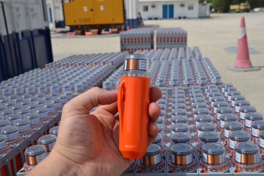
Launched to the market in mid-2020, this market-leading seismic nodal technology offers pioneering, high-density seismic imaging of the subsurface, playing a pivotal role in the exploration of new energy discoveries, and production optimization of existing reservoirs.
Seismic data acquisition is the process of gathering information about the composition of the earth below the surface using sound waves. This data is acquired using seismic receivers, which record the echo vibrations bouncing back from deep geological interfaces and turning them into an electrical signal. This signal is then processed to create 3D images of the subsurface to pinpoint where oil and gas reserves exist.
In addition to the state-of-the-art nodes created by STRYDE, the company also offers fast-track data processing. The solution pulls upon over 100 years of cumulative seismic experience from its team, to efficiently process the raw data recorded in the field to create images of the various layers of rocks and minerals found underground.
When combining STRYDE’s cutting-edge seismic technology with fast-track data processing, companies can now acquire subsurface insights far quicker than ever before at a significantly reduced price point and with less exposure to HSE risk. This enables oil and gas companies to optimize exploration programs and de-risk drilling decisions.
Out with the old...
-1.png)
Since the first oil boom in the 1970s, expensive and complex cabled seismic receiver systems have been used to deliver seismic surveys.
These multi-channel acquisition systems are conducted in what we now call cable array systems: a string of geophones in a line connected by multi-conductor cable, made up, typically of hundreds of wires in a heavy polyurethane jacket.
These cables consist of short sections, connected by power connectors, and usually determined in length by what a person could carry. With the introduction of 3D surveys, ‘distributed systems’ were developed to support the larger arrays of parallel lines of geophones. Modules called remote boxes digitized the signals from a handful of geophone groups and the digital data is sent through a data transmission to a central recording system where the data is checked and recorded.
As cabled geophones are heavy, bulky, and complex, they limit the density of the receiver sampling, which is why cabled stations are often separated by as much as 50m apart. The use of this technology often incurs unnecessary costs, risks, and inefficiencies for land seismic, especially in difficult terrains; these range from higher equipment purchasing costs, larger crew sizes being required, and more vehicles needed, to enhanced exposure to HSE risk, increased chances of technical downtime and reduced productivity.
Furthermore, the use of geophone arrays is a very common practice when using cabled systems, particularly because they increase the Signal to Noise of raw data and apply some pre-filtering, which can often reduce the final image quality and therefore the understanding of the subsurface. This is caused by known detrimental effects on data resolution and frequency bands due to the unrecoverable mixing of different geophone responses and traces, which can be corrected for when single sensor acquisition is used.
Now, seismic nodes are making large-scale, high-density, efficient, and low-cost seismic acquisition a reality.
In with the new...
-1.jpeg)
Until recently, cumbersome cabled seismic recording devices were the only solution for acquiring land seismic data needed to enable exploration and production projects.
Qualified geophysicist and Head of Processing at STRYDE, Amine Ourabah explains:
"STRYDE Nodes™ have been groundbreaking for exploration projects. We have replaced bulky, expensive equipment with lightweight, lower-priced, easily transportable nodes which enable high-quality imaging of the subsurface. Users benefit from significant cost efficiencies, while also dramatically lowering both the environmental impact and the health and safety risks of land seismic."

Despite the recent advances in seismic nodes and the efficiencies, they have brought with them, for some, the adoption of new, nimble technology like STRYDE’s miniature nodes has come with caution. This is mainly driven by the desire to use existing pools of cabled geophone inventory and a reluctance to change existing and successful ways of working – but with radical improvements to seismic operations enabled by using Nodal technology, this mentality is quickly becoming obsolete.
How Egypt can lead the way in land seismic operations
Since the 1907's, Egypt has continued to be a major energy player, with the country recently launching a round of bids for oil and gas exploration rights. However, as it stands today, a vast majority of oil and gas, and even mining exploration projects that occur in the region typically utilize cabled systems to acquire seismic data.
But, with a goal to increase its reserves and maximize hydrocarbon recovery on existing fields, oil and gas companies in Egypt are beginning to have their head turned by the possibilities and efficiencies delivered by nodal technology.
With over 500,000 STRYDE Nodes™ delivered and utilized in over 39 countries to date, the STRYDE Node™ has become the market-leading nodal solution for land seismic. The technology is also starting to make a name for itself in Africa and across the globe, with more than 365,000 STRYDE Nodes™ being sold or leased in 2022 alone, as its team of experts have worked closely with partners to map the subsurface of jungles, deserts, forests, mountain ranges, and cities across 6 continents.
Chief Commercial Officer of STRYDE, Cameron Grant shares the environmental and economic benefits that the nimble technology can promote:
"Unlike their predecessor, and industry stalwart, cables - our highly reliable Node can be quickly deployed in the tens of thousands, covering extremely large areas of land at pace. Utilized by local teams, on foot, STRYDE Nodes™ offer a more efficient, safer solution to our clients, without compromising on data quality. The ability to cost-effectively acquire high-density seismic allows for superior subsurface imaging, allowing customers to radically improve their geological understanding, and in turn, gain a much better picture for far greater returns on reservoirs.”

Efficient and affordable large-scale surveys are now a reality, enabled by volumes of inventory that can be deployed in the field, at a fraction of the cost of cabled systems.
Mr. Grant added:
"After decades of relying on miles and miles of cables, we’re asking the sector to trial the latest and greatest to fully appreciate the powerful data and efficiencies that our miniature nodes can offer."
Getting access to the subsurface image far quicker than ever before...

Once the data has been acquired, a huge amount of data processing is required when taking signals from the earth to transform it into an image that can be understood.
Mr. Ourabah explains:
"Initial data collected is so complex that in most cases, it can take months or even years to be able to analyze it to a standard that can then be shaped into an image for consideration and project planning, but here at STRYDE we can offer this in a third of the time by leveraging both the power of high-trace density and high-performance computing. "
The technology has been widely adopted as a receiver technology of choice in the Middle East and Africa region, with the company recently announcing an agreement with Africa Geophysical Services LLC, a land seismic data acquisition and processing company in Oman, to supply 154,000 of its nodes for projects in Oman and Africa. Africa Geophysical Services, which has a presence in Oman, India, Tanzania, Egypt, Dubai, Uganda, Turkey and the United Kingdom, will use STRYDE Nodes™, expertise and training services to obtain data for oil and gas exploration projects in Oman and Africa.
Illuminating a better and more prosperous future
STRYDE’s ability to reduce CAPEX and OPEX costs, while significantly improving the image uplift has led to more informed decisions, and successful exploration and production optimization projects.
STRYDE’s cost-effective offering opens a world of opportunity for these critical resources, allowing ambitious market-leading operators to explore large-scale survey locations or projects previously untapped because the exploration phase was either uneconomical or impractical.
STRYDE Nodes™ might be small in size – but their demand from the market is rapidly growing, and their capabilities are even bigger.